AS29 - Advanced Sharpie 29'

Lollygag is a, professionally designed, home-built sailboat (with modifications.) She is a Catboat Yawl with a Gaff Rigged Main and Marconi Mizzen.

Saturday, March 19, 2011

St. Catherines Island, GA; March 19, 2011

Link to anchorage near Saint Catherines Island

Leaving this morning, you could see commercial shrimp boats in another part of the channel

Boat dock at low tide going into our anchorage

Same boat dock leaving our anchorage at high tide

Today's journey when through marshes, past islands and dense forests. 
It felt isolated without seeing houses and only an occasional boat.
The water was calm with enough breeze to keep the hungry bugs away.

Friday, March 18, 2011

Crescent, GA; March 18, 2011

Link to anchorage near Crescent, GA via Google Maps


We are mid way along Georgia's coastline.
Our travel today wound us through marshes, a wildlife refuge, open Sounds and twisty narrow channels.

Saltwater Marshes

Changing scenery with not as many Palm trees

Thursday, March 17, 2011

Northeast of Brunswick, Ga on Jove, Creek; March 17, 2011

Link to anchorage in Jove Creek, GA via Google Maps

Jekyll Island is Georgia's largest and southernmost barrier island.

Crossing St. Andrew Sound

Ship at the mouth of St. Simon Sound

What makes a body of water a "Sound"? I had to look it up.

Seems like a "Sound" is interchangeable with "bay" as most sites agree that both are indentations along an ocean.

Sounds are often larger, deeper and less protected....or so I've read.

However, a channel or strait between two bodies of land is sometimes identified as a Sound.

Very confusing.

There seems to be some some vague guidelines, but what I've learned it what we thought in the first place . . . it's the whim of the map makers. 

Sound is an Old English word meaning "to swim" which suggests to me that a person could swim across it. . . . . . . . thanks, we'll stay in the boat!

Wednesday, March 16, 2011

Hello Georgia!; March 16, 2011

Link to first anchorage in southeast Georgia via Google Maps

Welcome to Georgia!
This marker is on the boarder between Florida and Georgia.
 I was hoping to see a welcome sign like you have on highways.

The channel today was wide and zig zag. 
At times it felt like we were part of a boat parade.

This cruise ship, schooner, and tug were on the channel.


Channel markers got big close to the submarine base.


Naval Submarine Station at Kings Bay

Keep Out! Restricted Area!

Security is there to keep boats out - 
and if you get too close, the Coast Guard calls on the radio and if you're like this poor guy and apparently don't have a radio, they  close in and chase you away.

Last Anchorage in North Florida; March 15, 2011

Link to our last anchorage in northeast Fl via Google Maps

Quiet place to spend the night and good for birdwatching.

You can see this crab pot and buoy when the tide is low.

You pass by Mayport Naval Station at the mouth of St Johns River


Palm Cove Marina, FL; March 14, 2011

Link to Palm Cove Marina in Jacksonville, Florid

We needed to stop for gas and decided to spend the night at a marina on the east edge of Jacksonville, FL.

 
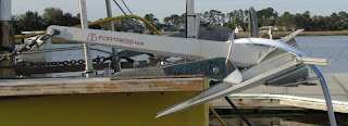
We have 6 anchors on board.
This is our main anchor;
a 33 pd Rocna
Our other main anchor is a Fortress FX 27
The same type on the stern.


These are 2 homemade 25 pd Fisherman anchors. 
They are suppose to be good for holding in rocks. 

The other anchor on board is a Bruce.

The marina had their own dredger to keep the channel open. 
At low tide, the channel was less than 3 feet.

Monday, March 14, 2011

Deep Creek State Forest; March 13, 2011

Link to anchorage in Deep Creek State Forest, FL via Google Maps

Traveling north on the ICW along the east coast of Florida
Matanza River is wide in places


Tide table shows the range between 3 - 4 feet
in this area.
Houses have long piers leading to the boat.
St. Augustine, Florida

Tour boat and a fort at St Augustine

You head towards the mouth of the St Augustine inlet before turning north on the ICW

Lighthouse on the ocean side of the barrier island


Ever present dolphin
 
Our VERY unscientific observation is that the dolphin on the ICW behavior is different than what we observed in the Gulf on Mexico. On the Gulf, the dolphin came up to the boat, surfed on the bow wake, and would turn and seemed to make eye contact with you. They were generally in larger groups. Here on the ICW, they are in smaller groups and as you see in the pictures, they surface a few times and then dive. They get our attention when one jumps. Interesting.